LATER


Detailed Weather 


Acronyms

We Updated and Moved - EZWX.INFO
Now works on iPad, iPhone, Tablet, Smartphone, and desktop. Links work even when the connection is dropped!

What's the Weather doing now? These are the sites that best depict current weather. Click on image to go to the site


Surface Visibility Depiction - Unisys Weather

AFC from METARs
LIFR   IFR   MVFR  
(icg)                 PIREPs             (turb)
LGT MDT SEV              LGT MDT SEV    

sfc_depict_inv.gif (44938 bytes)

Best Current Surface Radar - NOAA


Local forecast by
"City, St"or
zip code
  
Additional Views 

Additional Links


Laughlin AFB Brownsville Corpus Christi Austin/San Antonio Caribou Key West Seattle/Tacoma Spokane Portland Medford Pendelton Boise Missoula Great Falls Glasgow Minot AFB Bismark Grand Forks Duluth Aberdeen Rapid City Billings Eureka Beale AFB Sacramento San Francisco Bay Area San Joaquin Valley Vandenberg AFB Los Angeles Santa Ana Mountains Edwards AFB Reno Elko Las Vegas San Diego Yuma Phoenix Tucson Flagstaff Cedar City Salt Lake City Pocatello/Idaho Falls Riverton Grand Junction Cheyenne Denver/Boulder Pueblo Albuquerque North Platte Goodland Dodge City Amarillo Cannon AFB Holloman AFB El Paso Lubbock Midland/Odessa San Angelo Laughlin AFB Brownsville Corpus Christi Austin/San Antonio Central Texas Dyess AFB Frederick Vance AFB Oklahoma City Dallas/Fort Worth Tulsa Wichita Hastings Topeka Omaha Sioux Falls Minneapolis Marquette Gaylord Green Bay La Crosse Des Moines Quad Cities Milwaukee Grand Rapids/Muskegon Detroit Chicago Kansas City/Pleasant Hill St. Louis Springfield Central Illinois Paducah Western Arkansas/Fort Smith Little Rock Memphis Shreveport Houston/Galveston Lake Charles Fort Polk Brandon/Jackson New Orleans/Baton Rouge Caribou Burlington Portland Montague Boston Albany Buffalo Binghamton Upton Northern Indiana Cleveland Philadelphia State College Pittsburgh Indianapolis Wilmington Fort Campbell Jackson Dover AFB Sterling Charleston Wakefield Blacksburg Morehead City Raleigh/Durham Knoxville/Tri Cities Nashville Wilmington Greer Columbia Northern Alabama Atlanta Charleston Robins AFB Columbus AFB Birmingham East Alabama Jacksonville Moody AFB Fort Rucker Mobile Northwest Florida Tallahassee Melbourne Tampa Bay Area Miami Key West Evansville Louisville
National
Radar
Mosaic
Sectors
Loops

(click image)
Go to the Alaska sector loop Go to the Pacific Northwest sector loop Go to the Northern Rockies sector loop Go to the Upper Mississippi Valley sector loop Go to the Central Great Lakes sector loop Go to the Northeast sector loop
Go to the Hawaii sector loop Go to the Pacific Southwest sector loop Go to the Southern Rockies sector loop Go to the Southern Plains sector loop Go to the Southern Mississippi Valley sector loop Go to the Southeast sector loop

National Weather Service, NOAA
1325 East-West Highway
Silver Spring, MD 20910
Page Authors: Dennis R. Cain and Paul Kirkwood
Last Modified: January 13, 2003

Alternate Site 

These are the sites that best depict the trend of the current weather.Click on image to go to the site.

Best Looping Satellites - Nav Canada

IR & topography: large medium small
IR(infra-red: 10.7 �m): large medium small
Visible & topography: large medium small
IR + Visible: large medium small


Best Current Surface Radar - NOAA
  RADAR Coded Message Composite Image with Tops  
  Info
Loop
Lg Image
Lg Loop
NWS RADAR Site   /   Alternate
RADAR Observatons (ROB)

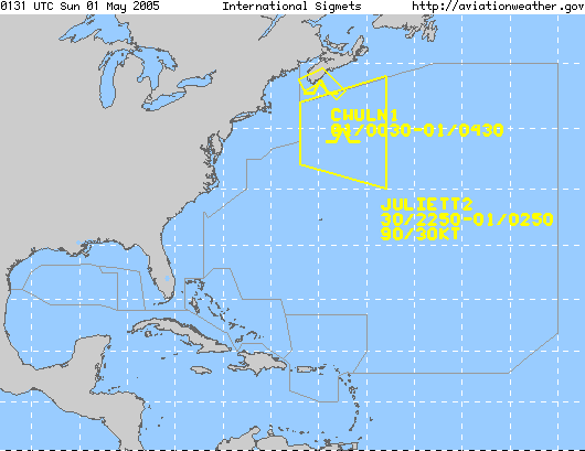
Best Convective Sigmets - Aviation Weather Center

AIRMET BLUE

SIGMET RED

Graphics:
Clickable Image
Clickable Image
 

Clickable Image

color hr
SIGMET/AIRMET, Intl SIGMET, Area Forecast, Low SIGWX Progs, Mid SIGWX Progs, High SIGWX Progs, CCFP, Convection, Turbulence, Icing, Winds/Temps (FD), Center Weather, TAFs, PIREPs, METARs, RADAR, Satellite - Domestic, Satellite - Intl, Flight Folder, ADDS, Standard Briefing, Experiments, Information, Aviation Links, Contact AWC,


Click Here for Experimental Turbulence Forcasts

Home

NATIONAL AIRSPACE SYSTEM STATUS
 
Disclaimer: While every effort is made to ensure accuracy, Proactive Information Corporation makes no representation as to the accuracy of, and cannot accept any legal responsibility for any errors, omissions, mis-statements or mistakes within the pages of this web site or on other web sites which may be linked to this site from time to time.
Proactive Information Corporation makes no warranties or representations (whether express or implied) as to the non-infringement of third party rights, satisfactory quality or fitness for any particular purpose.
In no event will Proactive Information Corporation or its officers be liable to you for any damages (including, without limitation, consequential, incidental or special damages, including lost profits or lost savings), or for illegal acts or actions, arising from the use of the pages on this web site or on other sites which may be linked to this site from time to time.

Send comments to General Information: safepic@safepic.com
Last Updated 17 January 1999
Copyright Proactive Information Corporation
2010

What's the Weather doing now? These are the sites that best depict current weather. Click on image to go to the site

NOTAMS

Home

NonRevwebsite.com

ad